Month: May 2018

Province to Lift Travel Restrictions

FIRE BULLETIN #9


Recent rain and improving weather conditions have allowed the province to lift travel restrictions in the eastern, central and western regions of the province with the exception of the Duck Mountains.  Motorized backcountry travel is not allowed between 10 a.m. and 8 p.m., and campfires are only allowed between 8 p.m. and 8 a.m. in the Duck Mountains.  Provincial resources including Manitoba Sustainable Development, Emergency Measures Organization and the Office of the Fire Commissioner continue to work on a number of fires around the province.  Ontario has provided 120 firefighters and Quebec has sent four water bombers.

Fire crews continue to work on the fire between the Little Grand Rapids First Nation and the Pauingassi First Nation, which covers over25,000 hectares andis about four kilometres from Pauingassi.  Some light rain has fallen on the area, which has helped the efforts but the fire is still not under control.  Crews have now completed the work of setting up sprinklers to protect homes at both the Little Grand Rapids First Nation and the Pauingassi First Nation.  Power remains out to the area and the evacuation order remains in effect for both communities.

The fires near the community of Ashern are considered under control, with crews remaining in the area to monitor and address a few hot spots.

Recent rain and high humidity assisted suppression efforts on fires near the community of Sapotaweyak Cree Nation but the community remains evacuated.

One new fire started yesterday and the total number of fires in Manitoba to date is 186, well above the 20-year average of 114 for this date.

A list of parks with campfire restrictions can be found at www.manitobaparks.com.  Visitors to provincial parks should check with park staff for the most up-to-date information.

A map of the areas affected and a detailed description of the provincial fire and travel restrictions can be found at www.gov.mb.ca/sd/fire/Restrictions/index.html.  Local municipalities may also implement burning bans or fire restrictions.  Check with local municipal offices or visit www.gov.mb.ca/wildfire/burn_conditions.html for more information.

For further general information on fire status, maps, burning permit cancellations or other restrictions go to www.gov.mb.ca/wildfire/or follow the Twitter account at www.twitter.com/mbgovnews.

For additional information on these restrictions, contact the nearest Manitoba Sustainable Development office.  To report a wildfire, call 911 or the T.I.P. line (toll-free) at 1-800-782-0076.

– 30 –

Motorized backcountry Travel Restrictions “REMAIN IN PLACE”

Manitoba Media Bulletin

May 18, 2018

FIRE BULLETIN #3

Manitoba Sustainable Development advises that recent rains and an improved weather forecast has allowed some burning restrictions to be lifted in southeast Manitoba, while some other restrictions still remain due to the high risk of fires.

For the eastern region, from PR 302 to the Ontario border and from the Trans-Canada Highway south to the U.S. border the daytime campfire restrictions have been lifted.  Motorized backcountry travel restrictions remain in place.

In addition, backcountry travel restrictions have been added to the Porcupine Provincial Forest as well as the area bordered by Lake Winnipeg and Poplar River, east to the Ontario border and south to the Wanipigow River.

Campfire restrictions have been lifted in the south Whiteshell Provincial Park campgrounds (Caddy Lake, Falcon Beach, Falcon Lake-Lakeshore, Falcon Lake-Toniata Beach and West Hawk).  Campfires in north Whiteshell Provincial Park campgrounds (Brereton Lake, Dorothy Lake, Nutimik Lake, Opapiskaw, Otter Falls and White Lake) are still restricted to burning between 8 p.m. and 8 a.m.  Be sure to check with the local campground office for the latest information.

All other travel and fire restrictions remain in place.  A list of parks with campfire restrictions can be found at www.manitobaparks.com.  Visitors to provincial parks should check with park staff for the most up-to-date information.

A map of the areas affected and a detailed description of the provincial fire and travel restrictions can be found at www.gov.mb.ca/sd/fire/Restrictions/index.html.  Local municipalities may also implement burning bans or fire restrictions.  Check with local municipal offices or visit www.gov.mb.ca/wildfire/burn_conditions.html for more information.

For further general information on fire status, maps, burning permit cancellations or other restrictions go to www.gov.mb.ca/wildfire or follow the Twitter account at www.twitter.com/mbgovnews.

For additional information on these restrictions, contact the nearest Manitoba Sustainable Development office.  To report a wildfire, call 911 or the toll-free T.I.P. line at 1-800-782-0076.

– 30 –


Fire Update Report, May 11, 2018

 Due to dry windy conditions and high fire dangers, all burning permits in eastern, central and parts of western Manitoba are cancelled. New permits will not be issued until conditions improve. Travel restrictions are also in place for eastern, central and parts of western Manitoba as well as the Mars Hill Wildlife Management area, and southern Manitoba parks. Campfire restrictions are also in place for all provincial parks in southern Manitoba. Visitors to provincial parks should check with park staff for updated information (www.gov.mb.ca/sd/parks/fire_restriction.html). Additional information on restrictions is available at www.gov.mb.ca/sd/fire/Restrictions/index.html

Fire crews continue suppression work on existing and new wildfires in eastern and central Manitoba.

Please exercise caution when in or near forested areas. If using an ATV in areas where backcountry travel is permitted, please remember to stay on developed trails, stop frequently to check areas around the engine and exhaust for debris and carefully dispose of any debris found. A small shovel, axe, and fire extinguisher should be carried with your ATV at all times.

Open fires are prohibited from April 1 to November 15 annually, except under a burning permit or in enclosed, approved fire pits such as grated campfire pits in provincial campsites where permitted. Activities in wooded areas involving fireworks or sky lanterns may also require written authorization during this time period in certain areas.

For information on required authorization or permits, please contact your local Sustainable Development office. Municipalities often implement their own restrictions. Please check with your local Manitoba Sustainable Development district offices and local municipal offices for information on burning bans or other restrictions.

A list of local Manitoba Sustainable Development offices is available at www.gov.mb.ca/sd/wildlife/about/who.html

Please report all wildfires to 1-800-782-0076 (TIPS / Wildfires) Please note the TIP line is only for reporting wildfires and not for general information).

ATV group encouraging riders to make Sandilands Provincial Forest their next stop for a perfect week

The Eastman ATV Association maintains 180 kilometres of designated trails in the Sandilands Provincial Forest.
by Jeff Johnson |

The Sandilands Provincial Forest.
— Photo courtesy of Eastman ATV Association.

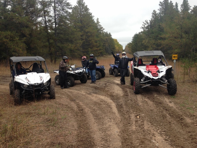
Two years ago, the Eastman ATV Association opened its trail in the heart of the Sandilands Provincial Forest.

The forest’s sand-based terrain grows all different kinds of vegetation, from shrubs all the way to tall pines. Association president David Lee said it’s a very attractive area to ride an ATV.

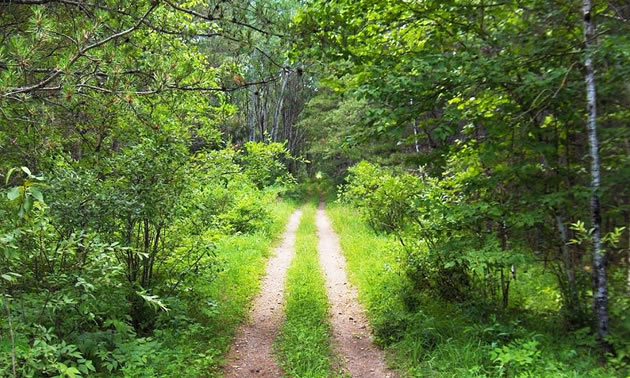
“There’s a lot of tight, twisty trails. Sand-based with some gravel, some interesting trails with a little bit of water on them, and it also ends up into a tight-packed trail with a clay base,” Lee said. “You’ve got a good variety of trails to ride out there.”

A popular site for ORVS

Lee said Sandilands has been popular with young riders for nearly 20 years, which pushed his group to see the area developed for ATVs.

“Due to the number of youth with ATVs in the area, there was a need to develop a designated trail system and the beginning of this started in 2009,” Lee said. “A group got together and the Eastman ATV Trail was getting redeveloped. Our vision back then was to have a designated trail on Crown land.”

Two years ago, that vision became a reality through the support of Manitoba Sustainable Development and other stakeholders.

“We were successful in securing one of the first trails on Crown land in Manitoba. There were other trails in the area before ours, but they were on rural municipality trails. They weren’t on Crown land,” Lee said. “So our trail and the Sandhogs Trail were the first to be developed on Crown land in the province of Manitoba.”

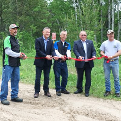
Members of the Eastman ATV Association cutting the ribbon at the grand opening of the Eastman ATV Trail in Sandilands Provincial Forest.
— Photo courtesy of Eastman ATV Association.

Looking back, Lee was amazed with the amount of work they put into getting the trail recognized by the Province.

“We never had a designated trail. Before, you weren’t allowed to maintain your trail. You could have the wheel touch the ground, but you weren’t allowed to cut a tree, move it off the path; you weren’t allowed to do any landscaping or change the ground which you ride on,” Lee said. “As a designated trail, we are able to maintain these trails and build them up to a safer standard, and one thing this has really developed is tourism. Now you got an area you can promote to tourist traffic.”

What tourists can expect

Lee feels any rider wanting to check out the trail network needs to come prepared by visiting the Eastman ATV Association’s website first.

“We strongly urge people to download the map because it is a trail and it is the responsibility of the rider to know where they are at all times,” Lee said. “The sign will show you around the trail but you need your map.”

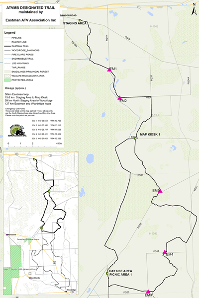
Map of the Eastman ATV Trail from ATV Manitoba.
— Photo courtesy of Eastman ATV Association.

Lee said there is a huge amount of land to cover in the Sandilands Provincial Forest, both on the Eastman ATV trail and the nearby Sandhog trail.

“Between the two clubs, you are looking at 180 kilometres of trail, so it’s a really good day ride,” Lee said. “You can ride our trail system which is approximately 90 kilometres. It’s set up in a loop, so you loop on out.”

Lee also encourages you to check out the trail managed by the Woodridge ATV Sandhogs.

“On the back end of our trail, there’s another trail system managed by the Sandhogs and that trail will take you into Woodridge,”  he said.

Woodridge is a small community built on the pulp and lumber industry in the 1900s. It’s also an ATV- friendly community.

“Woodridge has an ATV-friendly campground—you can take your ATV right up to the community store and buy fuel. There’s a great restaurant,” Lee said. “There’s a little hamlet where you can rent a room, so if you don’t have a camper, there are facilities available to stay overnight.”

What stands out on the Eastman ATV Trail?

Lee said there’s a lookout that can be found around the halfway point of the trail that dates back to ancient history.

“People can find a trail that will lead them to a ridge. It’ll look out to the north and you will be up higher than the rest of the area,” Lee said. “This is actually the shores of Lake Agassiz (from) back in the Ice Age. So there’s some historic value there that you are looking at ancient shores of an old lake.”

Lee added their trail network also contains a portion of the old Dawson Trail.

“It was a historic trail back in the time of the settlers, so you could actually travel through history,” Lee said. “There are remnants of an old corduroy road. You’ll see logs sticking up sideways and sticking on the ground. Settlers of our country travelled on this exact trail we are riding on today.”

For people willing to explore, Lee said you can find plenty off the beaten path.

“Another highlight is an old trappers shack. We call it the Red Roof Trappers Shack and it’s just a little bit off our trail,” Lee said. “It was a trapper’s destination point and there were people trapping out of there making a living.”

You can find a map of the Eastman ATV trail at https://eastmanatv.com/. You can also visit http://woodridgesandhogs.ca/sandhogs-trail-map-2016/ for a map of the nearby Sandhog trail.

Scroll to top